
Ecosystems Biodiversity by Remote Sensing
Start Date
02/05/2023
End Date 31/12/2025
End Date 31/12/2025
Contact Person
Gaia Vaglio Laurin
Email gaia.vagliolaurin@cnr.it
Email gaia.vagliolaurin@cnr.it
Partner
Università della Tuscia, ENEA, EURAC
Funding Organization
Itineris, PRIN
Monitoring and studying natural ecosystem is critical for biodiversity conservation, also in view of climate change impacts. Biodiversity can be addressed at different levels (genetic, species, ecosystems): the ecosystem biodiversity includes functional variability, habitats and communities, ecosystem services, and ecological processes.
Remote sensing is a powerful tool to study ecosystems, producing spatially explicit data and being able to upscale local measures over broad ranges.
Project activities include the use of innovative remote sensing data (from satellite, airborne and UAV) to characterize: (a) Ecosystem Functional Properties (EFP) and functional traits, (b) Habitats, e (c) Biodiversity indices.
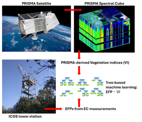
- The Ecosystem Functional Properties line develop models that integrate data over biochemical fluxes of ecosystems (i.e. Gross Primary Productivity, Light Use Efficiency, Water Use Efficiency, ecc.) collected by international research infrastructures such as ICOS, FLUXNET etc., or functional traits of vegetation, with hyperspectral and lidar data from satellites (PRISMA, EnMAP, GEDI etc.). The EFPs describe productivity and efficiency in resources use (water, carbon, light) of natural ecosystems, while functional traits represent features about morphology, ecology, and phenology of species.
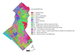
- The Habitats line integrates hypespectral, multispectral, and lidar data to advance in ecosystem classification producing a high thematic resolution level of detail, thus classifying habitats and species dominance in biodiversity valuable areas (Natura 2000).
- The Biodiversity indices line, e.g. species or traits richness and abundance, establishes relationships between spectral response from multiple satellite data and biodiversity as measured on the ground (Spectral Variation Hypothesis).
Media
| Web | Go to Website |
| Download PDF |