
A study by the Institute of Research on Terrestrial Ecosystems of the National Research Council of Italy (CNR-IRET) has demonstrated the effectiveness of hyperspectral data from the Italian Space Agency’s PRISMA satellite and Lidar information in monitoring forest habitat diversity with high detail and accuracy
Remote sensing technologies based on PRISMA and Lidar data can significantly improve environmental and forest habitat monitoring, supporting more precise strategies for the management and conservation of European forests. This is demonstrated by a study published in the journal Ecological Indicators, conducted by scientists from the Institute of Research on Terrestrial Ecosystems of the National Research Council of Italy, the University of Tuscia, and Eurac Research.
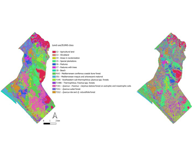
The multidisciplinary team, led by Gaia Vaglio Laurin, analyzed ten satellite images taken between 2020 and 2022, processing the information with artificial intelligence models (Random Forest and PLS-DA) to distinguish different habitats with high thematic detail. Compared to traditional methods, which rely on manual photo-interpretation, the combined use of PRISMA and Lidar enabled a detailed and semi-automatic classification of 14 types of forest habitats, even in contexts with very similar species.
As the authors explain, the Natura 2000 network covers over 37.5 million hectares of forests, hosting exceptional biodiversity. However, habitat monitoring is often sporadic and based on heterogeneous methods across different European countries, with insufficient data to precisely detail various habitats. The research team tested the combined use of hyperspectral PRISMA satellite data and Lidar data to analyze biodiversity in a Mediterranean forest within the Presidential Estate of Castelporziano (Italy), part of the Natura 2000 network. The goal was to improve vegetation mapping compared to traditional methods based on multispectral Sentinel-2 data.
The results show that PRISMA allowed for habitat classification with an accuracy exceeding 80%, compared to 54% achieved with Sentinel-2. The use of Lidar further improved the distinction between similar forests, providing crucial information on the vertical structure of vegetation. The researchers note that Mediterranean oaks (Quercus spp.) were particularly challenging to differentiate due to their similar spectral response.
These findings suggest that satellite-based hyperspectral monitoring should be adopted as a standard tool for biodiversity assessment within the Natura 2000 network and other protected areas. “Our work,” states Gaia Vaglio Laurin (CNR-IRET), “demonstrates that hyperspectral and Lidar data can revolutionize biodiversity monitoring in European forests, providing unprecedented details on habitats that are often difficult to distinguish using traditional methods. The accuracy achieved with PRISMA is significantly higher than that of multispectral data, opening new opportunities for ecosystem conservation.”
In the next steps, the authors plan to implement hyperspectral monitoring across other Natura 2000 habitats, exploring ways to harmonize methods across different habitats and countries. At the same time, they aim to utilize PRISMA time series, incorporating data from different seasons to study ecosystem evolution over time and further improve habitat classification. These techniques could contribute to developing more targeted conservation strategies based on more precise data on forest habitats. “The adoption of these tools,” conclude the scientists, “could enhance forest management, especially in the context of climate change, which is putting many protected areas at risk.”